|
||||

 |
||
|
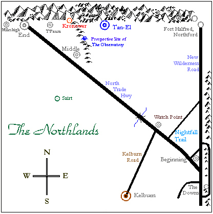
The Northlands
Key to the Map: Grey (Light Blue) = Dunadorian (Highways); Red = Fire Giant; Dark Blue = Tan-Elian; Green = Elven; Brown = Kelburnian Note that map is not to scale, for clarity purposes. The vertical distances have been greatly exaggerated. The Hadarna Mountains form the northern border of the map, and the Dragonsteeth Mountains form the eastern border. Mileshigh; and the area from End to Middle, west of Tesla Ridge; as well as the area north of the North Trade Highway from Watch Point to Fort Halfred, and to the Downs, are Dunadorian-held territory. South of the NTH and north of Kelburnian lands are the lands of Elves and other races. The Fire Giants claim some regions of the Hadarna Mountains, as does the independent City-State of Tan-El. Kronower Mining Colony is a rebellious splinter group of the Fire Giant Central Government. Tan-El claims the land from Tesla Ridge in the west to the NTH and a short distance to the east as well, though this has not been strictly enforced. If you have questions about the geography of the Northlands, they can be directed to Governor Faranyn, Middle-of-the-Road, or to the Council of Tan-El. |
||
|
|
|
|
|